Sunday, December 4, 2011

(Ch18) Race/Ethnicity

"Once the sole inhabitants of the state, American Indians in 2000 numbered 44,241, up from 28,000 in 1990. The black population is also small, 165,063, or 3.8% in 2000; the percentage for Denver, however, was considerably higher (11.1% in 2000). Of far greater importance to the state's history, culture, and economy are its Hispanic and Latino residents, of whom there were 735,601 in 2000 (17.1%), up from 424,000 (under 13%) in 1990. Among residents of Denver, 31.7% were Hispanic or Latino in 2000. Of over 95,213 Asians (2.2%), up from 60,000 in 1990, 11,571 were Japanese (down from 15,198 in 1990); 16,395 Korean (up from 12,490 in 1990); 15,457 Vietnamese (more than double the 1990 total of 6,679); 15,658 Chinese (up from 9,117 in 1990); and 8,941 Filipino. The population of Pacific Islanders was estimated at 4,621 in 2000. In all, 369,903 residents, or 8.6% of the state population, were foreign born in 2000."


The above is a chart that shows the distribution of 'whites' in Colorado. The American Indian population greatly conquered all other existing races in Colorado many years ago. However, in today's demographics, It is now occupied by primarily whites and Hispanics.
Also, the Peterson air force base is located at Colorado Springs in El Paso County. I thought i would talk about this briefly because I have actually visited it and been on base. It is extremely big and beautiful, hugging the mountains base and goes up into the mountains as well. While i visited Colorado with an Ex girlfriend of mine, her uncle and aunt are both in the military. So we got to get onto the base and drive around and check out all of the statues, and planes, etc. It was an amazing experience. Also, while we were there, we shot archery on an actual archery range which was really cool because it is set up like a golf course. There are "holes" which are really targets that you go around to and pick your distance and see how close you get to the bullseye, (or in our case if you could even hit the target). The below picture is an ariel view of one section of the base.
PetersonAFB.jpg

Colorado Logging

In the 1870s and 1880s with the harvest of railroad ties and other products for construction of the transcontinental railroad, logging began in the ponderosa pine forest of the southern Colorado Plateau. Starting in the 1920s, chainsaws, logging trucks, and bulldozer made it much easier to harvest on stepper slopes. Below is a picture taken in 1904 of the big pines.
Logging near Flagstaff 1904
In the 1940s-60s, road building dramatically increase in the Colorado Plateau and the West. To insure that the timber supply would last, harvesting large trees were reduced by distributing the cut to two or more entries. This meant that only 1/3 to 2/3 of the available harvesting area was allowed. Ultimately, "stem density increased while tree size and age decreased."
Once the 1970s and 80s came around, timber management practices continued to increase the "even-aged management." This focused on the visual quality, wildlife, and riparian zones and water quality. They wanted to make sure that they were not moving too fast, thus destroying the animals and wildlife.
In 1969, the National Environmental Policy Act (NEP A) was passed along with the FLPMA, Federal Land Policy and Management Act which restricted many management activities in federally-administered forests.

Thursday, December 1, 2011

Kite Boarding Colorado

Kiteboarding or kitesurfing is the latest water sport sweeping the globe in the new millennium. If you have seen someone kiteboarding you know that not only does this sport look amazing but it is fun to watch. Many kiteboarders became enthralled and obsessed with learning this sport after seeing it for the first time. “…but it looks so easy” is a common statement I hear from students who thought they would be riding in the three hour lesson. The truth is kiteboarding is really not that hard. It is multitasking of wakeboarding and flying a kite. And learning to safely launch and fly kiteboarding kites takes some time. A minimum of about 3 hours of lesson time is a must. There is no bunny hill in kiteboarding; at any second the wind can pick up and you are on the triple black diamond. The first goal of new kiteboarders should be safe and independent. As an avid kiteboarder myself, I can agree that this sport is no joke. At any given minute the weather can shift on you causing a situation that may be potentially fatal.

Ethnicity in the Southwest Boarder Area

The Southwest's American Indian population is culturally diverse. The largest tribes are the Navajo in the "Four Corners" area, where the states of Colorado, Utah, Arizona, and New Mexico meet; several Apache tribes in Arizona and New Mexico; the various Pueblo groups in New Mexico; the Papago in southern Arizona; the Hopi in northwestern Arizona; and the Utes in southwestern Colorado.
Most of the American Indians are found in the major reservation areas centers on the four corners. The largest amongst all of these is the reservation which spans 62,000-square-kilometers, is home to the Navajo which has 10 times the population of any other reservation. Arizona and New Mexico together are the home fro about 300,000 American Indians. Many rural counties of the lower Rio Grande Valley and most in southern Colorado and eastern New Mexico have lost population during the last few decades, sharing the fate of other strongly rural areas in America.


The Empty Interior

This area stretches from the Eastern Rockies to the Sierra Nevada of California, to the Cascade Range of the Pacific Northwest and into Alaska. It is known to be as the largest area of sparse population in AMerica. The Rocky Mountains "still have remnants of glaciation found in the central Rockies and the Sierra Nevada's" (Birdsall, etc..). The South Platte River is a river that is formed from the glaciation of the Rockies and heads through all Denver. The Colorado river provides water for California, Nevada, Arizona and couple other western states. Although the empty interior has a high level of Mormon influence, Colorado only has an average of 2% percent of the population survey practicing the Mormon faith according to the Pew forum. The federal and state government own about 43% of Colorado, with a lot of land being dedicated to forest and parks. In these forest and parks, there are tons of wildlife that live there.

Wednesday, November 30, 2011

The Great Plains

The Great Plains of North America is a somewhat triangular area covering 1.4 million square miles that extends for about 2,400 miles from Alberta, Saskatchewan, and Manitoba southward through Texas into Mexico and approximately 1,000 miles from foothills of the Rocky Mountains eastward to Indiana. Rainfall increases from west to east, resulting in different types of prairies, with the shortgrass prairie in the rain shadow of the Rockies, mixed-grass prairie in the central Great Plains, and tallgrass prairie in the wetter eastern region. The Great Plains region covers, roughly, the eastern 2/5 of the state. The land is flat and dry, sloping gently upward from east to west to meet the Rocky Mountains. This eastward-sloping, treeless, semi-arid, shortgrass plateau's annual rainfall is between thirteen and twenty inches, and the region's continental climate creates an environment of extremes: excessive heat and cold, and violent weather patterns.

The Agriculture Core

Due to the location of Colorado, there are limited crops that are able to be grown. The main focus of crops deal with growing corn, hay, and wheat. "Today, 40 percent of private land in the United States is used for agriculture. While 24 percent of that land is in the Rockies, the region produces only eight percent of the total agricultural commodities in the United States" (USDA). The agricultural core covers many states and includes Colorado, the following picture depicts the Corn for Grain Harvest acres.
Because corn flourishes in Colorado there are many corn field mazes around the area that help bring tourism to the area and other a fun activity to help the corn field farms grow. Like the The “Crazed Cornfield Maze” which is a 20 acre corn field maze that will have you twisting and turning in tall corn! This is a great outdoor event for all ages.

The colorado Desert (ch10)

The Colorado Desert is a part of the much larger Sonoran Desert, which extends across southwest North America. It expands from the Mexican border in the South to the Mojave Desert in the North and from the Colorado River in the East to the peninsular mountain range in the West, which is approximately 7 million acres. It is the second largest least populous of the ten bioregions, with a population of about 375,000, according to the 1990 census figures. The Colorado Desert is of a much lower elevation than the Mojave Desert and much of the land lies below 1,000 feet. The Mountain peaks barely pass 3,000 feet and the common habitat includes sand, palm oasis, and desert wash. The summers are hot and dry and the winters are cool and moist. The Colorado River flows along the entire eastern area of the bioregion which it meets with Arizona. Specific species known to inhabit the area are animals like the Yuma antelope, ground squirrels, white singed doves, muskrats, deer, bobcats, and raccoons.
This picture depicts the sandy dunes throughout the desert.
Colorado is also home to thousands of snakes because of the hot weather and ideal sand pits which makes nice homes for snakes.

Wednesday, October 12, 2011

ch9 Dever Colorado

:The Mile High City:
Denver is centrally located and lies in the foothills of the Rocky Mountain region. Located on high plains at the eastern base of the Rocky Mountains, Denver has a sunny, cool, dry climate. The sun shines 300 days a year and the usually mild climate and nearby Rocky Mountain playground have made tourism one of the Mile High City's economic mainstays. With a lower cost of living compared to most major cities, exemplary health care and world class medical research facilities, massive rapid transit expansion plans, and abundant cultural and recreational opportunities, Denver is one of the nation's best cities.

The Rocky Mountains & Beer

The Rocky Mountains stretch more than 3,000 miles from the northernmost part of British Columbia, in western Canada, to New Mexico, in the southwestern United States. The major countries regions that are contain the mountains also include: Wyoming, Utah, Colorado, Alberta, and Idaho. They were formed anywhere from 80 million to 55 million years ago by the Laramide orogeny. Since then, erosion by massive glaciers and water have carved the mountains into unbelievable valleys and peaks.


What could be better then then beautiful mountains, views, and landscapes? You guessed it...
BEER
Colorado is home to the largest single brewery facility in the world. The Coors Brewing Company is a regional division of the world's fifth largest brewing company.
...you can see from the picture, the size of the brewery.

Monday, October 10, 2011

Manufacturing


The Product Development and Manufacturing (PDM) Core offers product translational services to academic, government, and industry partners for the development and manufacture of vaccines, therapeutics, and diagnostics used in preclinical animal studies and phase I and II human clinical trials. The PDM Core's product development department provides prelim product characterization and formulation,
The PDM Core’s quality system, maintained by the Quality Control and Quality Assurance Departments, provides testing, validation, and auditing for GLP and cGMP-compliant projects, as required by the Code of Federal Regulations. Product release testing of manufactured products, including safety, stability, purity, potency, identity, and sterility testing, is performed as per the United States Pharmacopeia (USP), where applicable. Procedural validation is performed by documentation review and systematic inspections. Auditing services for GLP projects are available for outside projects.

Megalopolis

Huge areas of settlements can be found in the Front Range that goes from Denver to Casper, Wyoming and then down into Santa Fe, New Mexico that connect along interstate 25. However, it is not part of eastern Megalopolis. This region cannot contend with the eastern Megalopolis, but population is supposed to rise due to its high metropolitan setup.

-With retail businesses having a projected 5 percent increase in 2011 and the median home prices increasing around 2 percent, the recession did not hit Denver the hardest according to the metro Denver economist.

-People see potential as Denver being a strong economic city, so tons of development is going into the cities business infrastructure. Other pull factors include the safety of living and the cities environmental background that include denying the right to have the Olympics in 1967 because of environmental issues.

-Another thing that helps make Denver such a largely populated region is the fact they have a lot of sports teams that include the Colorado Rockies, Denver Nuggets, Denver Broncos and the Colorado Avalanche.

-Like every city in the country, sprawl is happening at a very rapid pace into mountains and nearby forest.

Human Activity

The first European settlement in Colorado was made by the Spaniard Francisco Escalante in 1776. The man who first stepped foot onto the land was believed to have been James Pursley, a fur trader in 1804. Part of Colorado was turned into the United States control as a part of the Louisiana Purchase. Some of it was then added to Texas after it won independence from Mexico in 1836. And the Western portion was claimed by Mexico in 1848. In 1858, the gold hunting began in Colorado and this brought a movement to form a territorial government. this became complicated due to the fact that parts of the territory was claimed by Kansas, Utah, New Mexico, and Nebraska. however, congress gathered parts of all the states together and soon the territory was called Colorado and achieved statehood in 1876.

Religion in Colorado began with the Spanish explorers who had a claim to the land, but who did not settle, were Roman Catholic, but the first American settlers were mainly Methodists, Episcopalians, and Lutherans. Roman Catholics make up the biggest group in the state with 752,505 members. There were about 72,000 members in the Jewish community in 2000. That same year there were about 72 Buddhist, 7 Hundu, and 12 Muslim congregations in the state. Roughly 60% of the population were not counted as members of any religious organization.

Colorado's Geography

Colorado has a Longitude of 102°W to 109°W and a Latitude of 37°N to 41°N. Colorado is 380 miles long and 280 miles wide. The geographic center of Colorado is located in Park County, 30 miles NW of Pike's Peak. Colorado is bordered by Wyoming and Nebraska on the North. And to the South is New Mexico and Oklahoma. The East side is bordered by Nebraska and Kansas and to the West by Utah. Thus, making Colorado a landlocked state. The Southwest corner meets Utah, Arizona, and New Mexico. This spot is best known as the Four Corners..
and..,
Colorado covers 104,100 square miles of terrain making it the 8th largest state of our 50 states. It only has 371 square miles of area covered by land and 103,730 square miles of land. The highest point in Colorado, and in the Rocky Mountains, is Mt. Elbert at 14,440 feet above sea level. Colorado is home to more mountains 14,000 feet or higher then any over state. It is home to the Colorado River, the Rio Grande, the Arkansas River, and South Platte River. It is also home to the Grand Lake, Blue Mesa Reservoir, and John Martin Reservoir.
Colorado River...

Colorado's Regional Division

Colorado’s cities and towns range from gleeful bastions of nightlife and big-city attractions to laidback affairs with tucked-away vistas and history-laden vacation destinations. Graced with a diversity of terrain – from the sun-bathed fissures of western Colorado to the sky-grabbing peaks of the Rocky Mountains and the swaying grass prairie of the Eastern Plains – every corner of Colorado provides a new adventure. Consider a lakeside stay in towns like Grand Lake and Gunnison, or indulge in the raucous downtown exploits of Denver and Colorado Springs. For a slower pace, stroll the thoroughfares of mountain towns like Telluride and Estes Park or visit our array of historic small towns, including Burlington, Pueblo and Julesburg...

Colorado has seven main regions that it is divided into. They are as follows:


Denver Metro Area
Denver-Metro
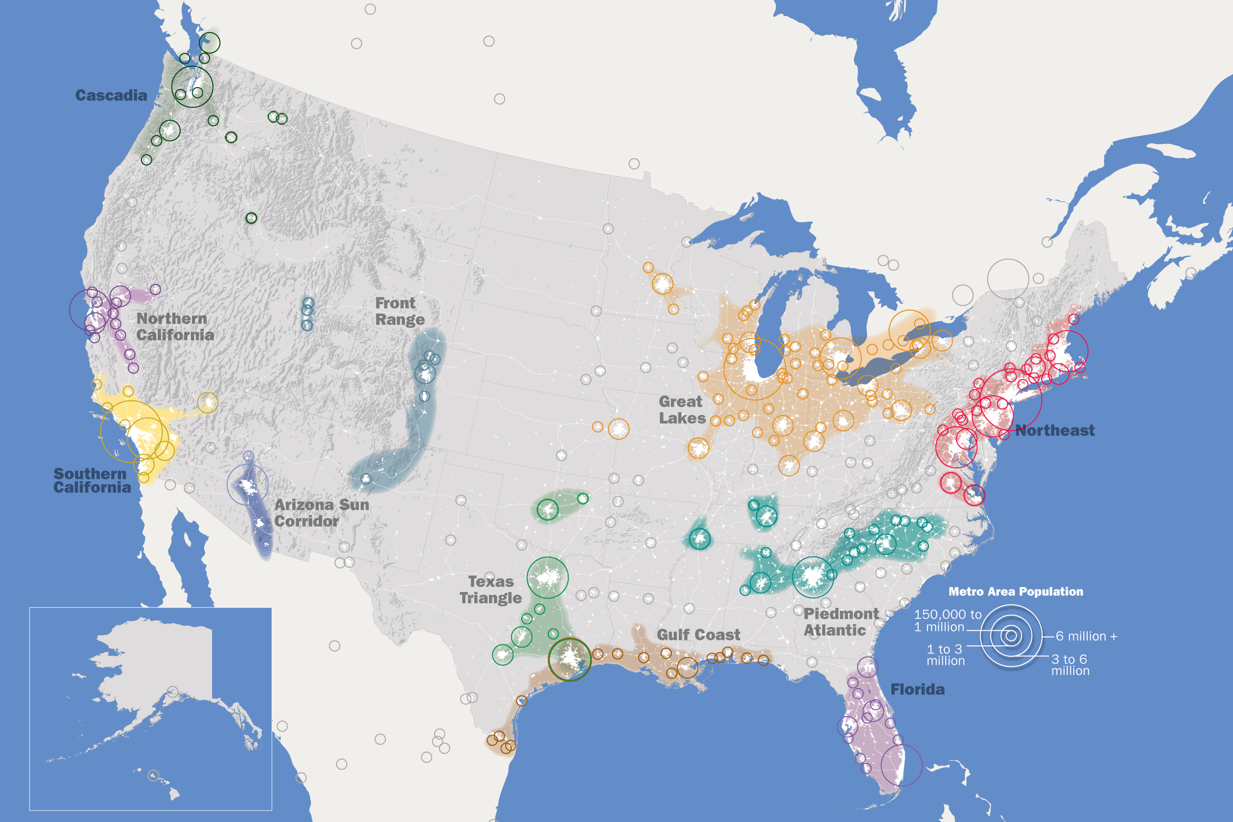
The Denver metropolitan area consists of eight counties including all of Denver and Broomfield Counties and parts of Adams, Arapahoe, Boulder, Douglas, Elbert, and Jefferson Counties. The metro area stretches over 4,500 square miles from Golden to the west to Watkins to the east. The northernmost city is Longmont and the southernmost location is Castle Rock.


Foothills
Colorado-FoothillsGenerally the foothills are considered the higher terrain between 6,000 and 9,000 feet west of Denver that parallel the Front Range Mountains. The foothills stretch from Roxborough State Park north to the west side of Fort Collins. Evergreen, Morrison, Genesee, Nederland, and Red Feather Lakes are all examples of foothill locations.


Palmer Divide
Palmer-DivideThe Palmer Divide is a ridge of higher terrain that extends from the Front Range of the Rockies in central Colorado, eastward toward the city of Limon on the Eastern Plains. It separates the Arkansas and Missouri River basins. Cities along the Palmer Divide include Monument, Castle Rock, Parker, Kiowa, and Elbert. It is named after William Jackson Palmer who founded Colorado Springs in 1871.
Urban Corridor
Urban-CorridorThe Front Range urban corridor is the area immediately east and west of Interstate 25 from Cheyenne, Wyoming to Pueblo. More than 85 percent of Colorado’s population lives along the urban corridor within the Fort Collins, Greeley, Boulder, Denver, Colorado Springs, and Pueblo metropolitan areas.
Eastern Plains
Eastern-PlainsThe Eastern Plains (or just “Plains”) is considered all areas of Colorado east of Interstate 25. Sterling, Limon, Burlington, Lamar, La Junta, and Springfield are examples of Eastern Plains locations.
Front Range
Front-RangeSpecifically the Front Range in Colorado is the eastern most mountain range of the Rocky Mountains stretching from Pikes Peak to the Colorado/Wyoming state line. However, the term “Front Range” is used to loosely describe any area from the urban corridor west to the Continental Divide.
Mountains
MountainsAny location above 9,000 feet in elevation is generally considered a mountain area. There are three mountain regions in Colorado.


Wednesday, September 28, 2011